Why Is The Town Square Precinct Important?
The Square of today bears little physical resemblance to the original plan, but its purpose remains unchanged. The Square has always been, and continues to be, a public place at the heart of Bathurst.
Bathurst is in an enviable position through having an identifiable and original public square whose significance has been recognised and supported by Bathurst Regional Council as a once in a lifetime opportunity to open a new vision for the future development of the City’s centre.
The challenge, now, is to find ways of ensuring that this space has the potential to become the active cultural community and commercial heart of the City by providing a focus for daily activities, enjoyment, the arts and for appropriate public celebrations, performance and entertainment.
We have the opportunity to transform the Square into a ‘pedestrian accessible’ precinct, a place that is not only ‘people friendly’ but also interesting to visit by ensuring laneways link streets, and green spaces and alcoves are given a pre-eminent place in future planning.
The Square Through Time
Within the traditional lands of the Wiradyuri, this historic Town Square in the heart of today’s Bathurst CBD began as an undefined space bounded by Russell, George, Howick and William Streets.
Commissioned by Governor Ralph Darling in 1829, Major Thomas Mitchell produced the town plan for Bathurst – the oldest of Australia’s inland European settlements. This plan was published in 1833.
The axis on which the Square is founded however, began earlier still in 1815 when Governor Lachlan Macquarie proclaimed the Township and had Surveyor Evans lay out a tentative plan for a town. The axis was a geographical determinant, formed by a slight ridge that ran from the Governor’s flag staff at the river’s edge, in a south-westerly direction towards what is now Mount Panorama (Wahluu). This axial ridge line ensured that the site of the township would drain naturally to creeks on either side that flowed into the Macquarie (Wambool) River.
Mitchell’s Scheme, based on this axis, evolved into the present town layout illustrated on the 1833 plan. The Square itself was gradually lost as the town developed and land grants were issued to Government institutions, religious groups, and finally commercial interests. One third of the Square (previously occupied by the extensive Market building, demolished in 1909) was salvaged in 1910 by a group of citizens intent on creating a public space within the CBD – this area was named King’s Parade, following the death of King Edward VII.
The significance of this ‘lost’ Town Square became apparent during studies carried out for the Conservation Management Plan for the William and Howick Streets former TAFE College buildings in 20001. These heritage buildings, and many others of historic importance, were found to be within the Town Square precinct which formed their curtilage. A Conservation Management Plan for the War Memorial Carillon2 also demonstrated that the Town Square was its curtilage. It became clear that this precinct was an important historical item of State significance, worthy of further study and preservation.
One hundred years after the establishment of King’s Parade, another group of citizens (The Bathurst Town Square Group) recognised the importance of the original Square’s context and heritage contents as the future heart of the CBD in the growing and increasingly important City of Bathurst. A submission was made to the Geographical Names Board of NSW who officially gazetted the Bathurst Town Square and designated it an “Historical Area” on 20 September 2010.
Today, the Square continues to be endorsed by the Bathurst Regional Council and embraced by the people of Bathurst.
Who We Are
Formed in May 2009, the Bathurst Town Square Group, part of the Bathurst District Historical Society, is a community initiative to conserve the historic precinct bounded by Russell, George, Howick and William Streets in Bathurst NSW by establishing this unique space as the community and commercial heart of this Heritage City.
Our Statement of Intent has been recently reaffirmed to “understand the history of the Bathurst Town Square and its curtilage so as to enable people to celebrate that knowledge and to support the facilitation of the Town Square as a centre of daily public life”.

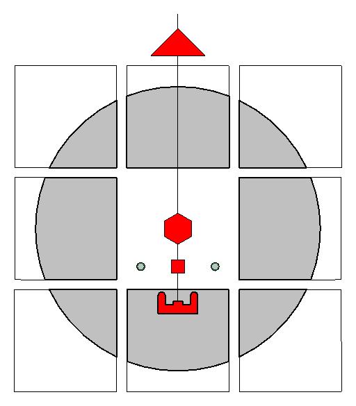
The Bathurst Town Square Group Logo
The Square is shown in the heart of the Bathurst CBD. A central axis extends through its centre back to the Flag Staff (red triangle) at the edge of the Macquarie/Wambool River, from which the township was set out by Governor Macquarie in 1815 and later by Thomas Mitchell, the Surveyor General.
At a height of 100 feet (30.48m), this axis now runs from the centre of the Court House Dome, in a line to the War Memorial Carillon, the Cathedral Bell Tower and the spire of the Cathedral, leading to the Flag Staff.
The grey circular area represents the general curtilage surrounding the Square and, at its centre, is the spire of the Cathedral, precisely where Mitchell had indicated the word Church in 1833.
It is interesting to note that the axis continues beyond the Court House across Machattie Park and the Rotunda, to the Keppel Street gates.
Footnotes:
- Conservation Management Plan for the William & Howick Street TAFE College Buildings – Bialowas & Assoc. Pty. Ltd for Bathurst Regional Council – 2000
- Conservation Management Plan for the War Memorial Carillon – commissioned by Bathurst Regional Council
